Published research highlights the nation’s first operational use of helicopter-mounted LiDAR for more precise, environmentally responsible mosquito control.
LEHIGH ACRES, FL, UNITED STATES, July 29, 2026 /EINPresswire.com/ — Lee County Mosquito Control District has become the first mosquito control program in the nation to operationally integrate helicopter-mounted Light Detection and Ranging (LiDAR) technology into routine mosquito control operations, demonstrating how advanced mapping technology can improve public health while reducing environmental impact.
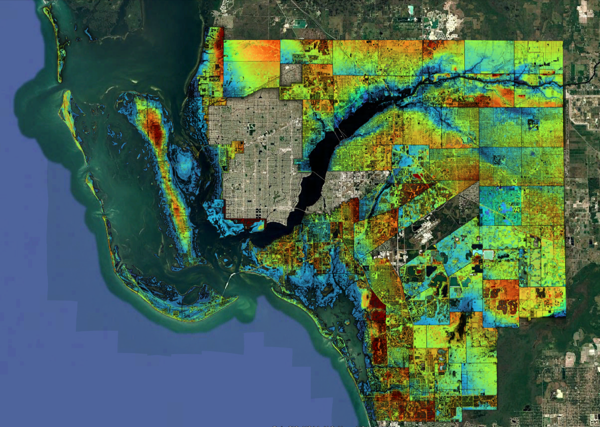
The achievement, recently published in the Journal of the American Mosquito Control Association, documents how the District uses helicopter-mounted LiDAR to create high-resolution, three-dimensional elevation maps that identify mosquito breeding habitats with unprecedented precision. The published research describes the project as the first documented large-scale operational implementation of LiDAR within a mosquito control program.
During the 2026 dry season, Lee County Mosquito Control District mapped approximately 456,000 acres of coastal and inland mosquito habitat using a LiDAR system mounted aboard an Airbus H125 helicopter. The technology generates centimeter-level elevation models capable of revealing subtle changes in terrain that determine where floodwaters collect and mosquito larvae develop. Those data allow field biologists to refine treatment boundaries with greater precision than previously possible.
Unlike conventional aerial photography or satellite imagery, LiDAR uses laser pulses to measure the earth’s surface beneath vegetation, producing detailed digital elevation models that reveal where water is likely to collect following rainfall or tidal flooding. These maps help distinguish productive mosquito habitat from non-productive areas, allowing mosquito control professionals to focus treatments only where they are needed.
“Precision has always been the foundation of effective mosquito control,” said Aaron Lloyd, Executive Director of Lee County Mosquito Control District. “LiDAR gives us an entirely new understanding of the landscape, allowing us to improve treatment decisions while reducing unnecessary applications. It represents a major advancement in protecting public health and responsibly managing our natural resources.” As LiDAR platforms continue to evolve and become more accessible, similar implementations should enable more programs to refine treatment footprints, reduce chemical inputs and non-target exposure, and provide the most precise mosquito control treatments that our industry has seen.
The technology offers benefits that extend beyond operational efficiency. By refining treatment boundaries, LiDAR helps reduce larvicide applications in areas that do not produce mosquitoes, minimizing unnecessary product use while maintaining effective mosquito control. The detailed elevation data also support hurricane recovery, flood assessment, habitat monitoring, and long-term environmental planning.
As mosquito-borne diseases such as dengue, West Nile virus, and eastern equine encephalitis continue to challenge communities across the United States, public health agencies are increasingly seeking technologies that improve surveillance, increase operational efficiency, and enhance environmental stewardship.
“Our responsibility is to provide the highest level of public health protection using the most precise tools available,” Lloyd said. “We believe this work demonstrates how emerging technologies can help mosquito control programs make smarter decisions while using resources more efficiently.”
The operational framework developed by Lee County Mosquito Control District could serve as a model for mosquito control agencies throughout the United States as LiDAR technology becomes more accessible and affordable.
Journal Publication
The operational note, Operational Application of Helicopter-Mounted LiDAR for Larval Habitat Mapping and Treatment Refinement in Lee County, Florida, was published in the Journal of the American Mosquito Control Association. The publication documents the first large-scale operational implementation of LiDAR as a routine mosquito control tool and outlines its potential to improve treatment precision while reducing unnecessary larvicide applications.
About Lee County Mosquito Control District
Lee County Mosquito Control District is an independent special district serving more than 860,000 residents in Southwest Florida. Through an Integrated Mosquito Management program, the District combines surveillance, aviation, biological control, larviciding, adulticiding, research, and public education to protect public health and improve quality of life while emphasizing scientific innovation and environmental stewardship.
Jenifer McBride
Lee County Mosquito Control District
jenifermc@leecountymcdfl.gov
Visit us on social media:
Facebook
YouTube
X
LinkedIn
Instagram
Why LiDAR is Important for Mosquito Control
Legal Disclaimer:
EIN Presswire provides this news content “as is” without warranty of any kind. We do not accept any responsibility or liability
for the accuracy, content, images, videos, licenses, completeness, legality, or reliability of the information contained in this
article. If you have any complaints or copyright issues related to this article, kindly contact the author above.

Media gallery